Greece does not have a coast to the Eastern Mediterranean sea
The EU cannot be allowed or has no jurisdiction or authority to determine the land, maritime and air borders of its member states with third countries. The "membership solidarity" cannot overrule the international law or justify the unilateral Greek Cypriot & Greek Helens claims.
Greece does not have a coast to the Eastern Mediterranean sea as the mainland and there is no continental shelf and exclusive economic zone limitation over the islands seperately.
Article 46 of UNCLOS; There is a condition that "the country must consist of archipelagos in order for the islands to have full authority" or it must be mostly made up of islands. In order for a country to be an "Islands State", it must be wholly or largely composed of islands. Various examples such as Indonesia, Sri Lanka, Cuba and the Philippines have been registered by the United Nations.
Contrary to appearances, Greece is not an "island state". Only 17% of the country's surface area consists of islands, islets and cliffs. In UNCLOS, there are no principles, principles or decisions that will make Greece an "Islands State" in the decisions of the International Court of Justice and the Arbitration Court.
Greece argues that the extreme points of its borders are Crete, Kerpe, Kaşot, Rhodes and Meis, and that it can make agreements with other countries on a midline basis by drawing a border over this line. Greece owns all the remaining waters between the islands as its own inland water.
The methodology for determining the maritime borders was formed as a result of the decisions of the Law of the Sea, the Court of Justice and the Arbitration Court. In determining the maritime border, fairness, equidistance, proportionality, the superiority of geography, non-closure, special and human conditions should be evaluated. In other words, while drawing a border, answers are sought for some questions, for example; 'Do you prevent another state from going to the open seas?', 'Is there a proportionality between the length of mutual coasts and the midline?', 'Has a fair agreement been made?
Meis(Kastellorizo) is an island that belongs to the mainland of Greece.Its distance from the Turkish mainland is 2 km, and its distance from the Greek mainland is 580 km.
Meis, which is located on the "Wrong Side" by looking at the middle line, cannot form a coast in the delimitation, cannot have a continental shelf and an exclusive economic zone other than territorial waters. In international law, except the territorial waters of the islands that are under the sovereignty of a mainland country; It has no continental shelf and EEZ.
The Greek islands cannot cut the Turkey-Libya coastal projection. The Greek islands, which are on the wrong side of the midline between the mainland and whose coastline is incomparably small with the Turkish mainland, cannot form a continental shelf and an exclusive economic zone.
According to the Lausanne Treaty in the Aegean, there is no such right as a continental shelf around the islands. There are 8 separate decisions taken as a result of dispute lawsuits filed since 1977 on the rights of the islands in the seas. According to maritime law, the islands do not have a say in agreements between mainland states.
We will not discuss the eastern Mediterranean with Greece. What common way will we negotiate with those who do not have a coast in the Eastern Mediterranean?
There are no disputed territories in the Mediterranean. The unlawful, unjust and maximalist demands of the Greeks cannot be negotiated.
Islands may have a Continental Shelf/Exclusive Economic Zone. However, the issue of having these rights is controversial. The EEZ is born in the oceans, the vast sea areas. For this reason, riparian states have been given the authority to establish sovereignty over a 200-nautical mile long sea area.
However, it is not possible to apply this scale in every marine area. For example, this length cannot be applied in the Aegean and Eastern Mediterranean. Because there is not enough sea area to leave a 200-mile sea area to the riparian states.That is why the Aegean and the Eastern Mediterranean are in semi-closed sea status.
The islands of Meis, Rhodes, Kerpe and Kasot; It is not on the Greek continental shelf, but on the Turkish continental shelf. These islands are less than 200 miles from mainland Greece. Islands that are on the continental shelf of the mainland do not have a continental shelf separately.
Maritime jurisdiction area for the islands belonging to the MAINLANDS in the Mediterranean, except for the TERRITORIAL WATERS; No Continental Shelf or Exclusive Economic Zone given. Compared to the mainland, the Greek ISLANDS cannot cut the gap between the 2 mainlands, namely the Anatolian mainland, the Asian and African continents.
Greece and Greek Cyprus, maritime claims are maximalist.They base on the entitlement of islands to EEZ/CS. Entitlement and Delimitation are not the same thing. Islands may get zero or reduced EEZ/CS if their presence distorts equitable delimitation.This is a fundamental international law principle.
In the absence of an agreement,“median line” as a delimitation method is only applicable for the “territorial sea"(UNCLOS Art.15) with the exceptions of historic title or special circumstances, not for EEZ or CS. For the delimitation of CS & EEZ, equity is a fundamental principle.
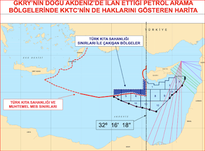
On numerous occasions, through the Turkish Permanent Mission’s notes, in particular notes Nos. 2004/Turkuno DT/4739 dated 2 March 2004, 2005/Turkuno DT/16390 dated 4 October 2005 The outer limits of Turkey’s continental shelf in the maritime areas in the eastern Mediterranean that are west of longitude 32º 16′ 18″E were defined in the Turkish notes verbales No. 2004/Turkuno DT/4739, dated 2 March 2004, and No. 2013/14136816/22273, dated 12 March 2013 and 2013/14136816/22273 dated 12 March 2013; and letters dated 25 April 2014 (A/68/857), 18 March 2019 (A/73/804) and 27 February 2020 (A/74/727), as well as the Permanent Mission’s numerous other letters, Turkey has submitted to the United Nations her ipso facto and ab initio legal and sovereign rights in the maritime areas of the Eastern Mediterranean.
Turkey's Permanent Mission’s Feridun Sinirlioglu's letter to the UNSG;
With my letter dated 13 November 2019 (A/74/550), it was registered that the outer limits of Turkish continental shelf in the Eastern Mediterranean follow the median line between the Turkish and Egyptian coastlines to a point to be determined in the west of 28° 00′ 00″E, in accordance with the outcome of future delimitation agreements among all relevant States, and with equitable principles, considering all the special and relevant circumstances based on international law. In line with Turkey’s above-mentioned position, the Memorandum of Understanding Between the Government of the Republic of Turkey and the Government of National Accord-State of Libya on Delimitation of Maritime Jurisdiction Areas in the Mediterranean was signed on 27 November 2019, which was ratified by both countries and subsequently entered into force as of 8 December 2019. I have the honour to convey the geographical coordinates of the outer limits of the Turkish continental shelf between Point F (34° 16′ 13.72″N – 026° 19′ 11.64″E) and Point E (34° 09′ 07.90″N – 026° 39′ 06.30″E) as agreed by the delimitation agreement between Turkey and Libya (see annex).
The Memorandum of Understanding, following the precedent of various judgments by international bodies of adjudication, is based on the principles that: (a) islands cannot have a cut-off effect on the coastal projection of Turkey, the country with the longest continental coastline in Eastern Mediterranean; (b) the islands which lie on the wrong side of the median line between two mainlands cannot create maritime jurisdiction areas beyond their territorial waters; and (c) the length and direction of the coasts should be taken into account in delineating maritime jurisdiction areas. In addition to the fact that the Greek Cypriot Administration is not competent to represent the whole island of Cyprus and as such cannot claim de jure and/or de facto jurisdiction or sovereignty over these areas, it is against the legal background explained above that the hydrocarbon activities carried out by Turkey lie entirely within the Turkish continental shelf. Any claim concerning the hydrocarbon activities of the Turkish Republic of Northern Cyprus should be addressed to the Turkish Republic of Northern Cyprus. Turkey, once again, emphasizes that it stands ready today, as it did in the past, to give its full support to ensure a just, equitable and peaceful solution to all pending issues, including the equitable delimitation of maritime jurisdiction areas with all relevant coastal States that it recognizes and with which it has diplomatic relations, in accordance with international law, in order to further contribute to the stability and prosperity of the whole Mediterranean basin. Turkey believes that building peace and stability in the Eastern Mediterranean will only be possible through dialogue and cooperation. I should be grateful if the present letter and its annex would be circulated as a document of the General Assembly, under agenda items 41 and 74, and published on the website of the Division for Ocean Affairs and the Law of the Sea, as well as in the next edition of the Law of the Sea Bulletin.


Comments
Post a Comment