The Turkish Republic of Northern Cyprus has an independent EEZ
They say how did the Turkish Republic of Northern Cyprus's license areas in the Eastern Mediterranean come from; the answer is here
The riparian states of the Eastern Mediterranean are attempting to declare an Exclusive Economic Zone to explore and exploit hydrocarbon resources. A coastal state can declare an Exclusive Economic Zone (EEZ) without being a party to the United Nations Convention on the Law of the Sea (1982 UNCLOS).
Although Türkiye and the TRNC are not parties to the United Nations Convention on the Law of the Sea (1982 UNCLOS) but they have the right to declare an Exclusive Economic Zone.
Article 74 of the 1982 UNCLOS on determining the boundaries of the EEZ; Article 83 which determines the boundaries of the Continental Shelf; Articles 122 and 123 on "Closed, Semi Enclosed Seas" and Articles 300 and 311 which regulate the non-abuse of the rights in the implementation of the Convention are related to the fair sharing of the regulation on semi enclosed seas in the Eastern Mediterranean.
Since the sea is a narrow maritime area, there are problems especially in the delimitation of the maritime jurisdiction area. Because according to the article 74 of UNCLOS, the EEZ limitation of the states with adjacent or opposite coasts should be limited by agreement by making a fair distribution.
The Greek Cypriot Administration does not have the legal right to declare an EEZ unilaterally. If there is more than one state and more than one people in a place, especially the controversial state cannot declare an EEZ unilaterally. If the Republic of Cyprus was legitimate and was a single state on the island, then could have declared EEZ.
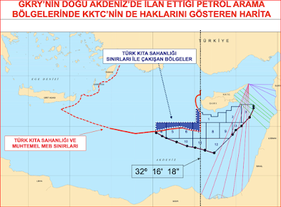
Parts 1,4,5,6 and 7 of the blocks that GCA unilaterally parcelized out by acting as the "sole ruler" of the island, together with the continental shelf of Turkey and also parts 1, 2, 3, 8, 9, 12 and 13 on the other hand, it is overlapped with the maritime border areas of the TRNC.
The TRNC has an independent EEZ. The maritime jurisdiction delimitation agreement is calculated by radiation. These lines are the coastlines where the radiations are made, where the TRNC can have the most maritime jurisdiction. This part of the Karpaz cape is the densest. In other words, the most radiation is made from this region.
Now, they say how the TRNC's license areas came out, where did they come from, if anyone says how the license areas given in the name of the TRNC were calculated, this is how they were calculated.
The map of the maritime jurisdiction areas is drawn in this way by the radiation that the owner will make from here. The maritime jurisdiction areas calculated by TRNC radiation are Syria, Lebanon, Israel, Palestine and Egypt, which are the "mutual coastal" states that are the basis for the EEZ delimitation.
The EEZ delimitation according to the article 74 of UNCLOS and continental shelf delimitation as stated in Article 38 those states with opposite or adjacent coas statue of the International Court of Justice. It accepts the principle that it is done with a treaty based on the rules of international law and with the aim of finding a fair solution.
For a fair solution to the 1982 UNCLOS and international judicial decisions; It refers to “an agreement to be reached between all parties concerned”. However, there is no regulation stating that the EEZ cannot be declared unilaterally.


Comments
Post a Comment